TECHNICAL MEMORANDUM
DATE: September 20, 2024
TO: Town of Wrentham
FROM: Shravanthi Gopalan Narayanan
Boston Region MPO Staff
RE: FFY 2024 Community Transportation Technical Assistance Program: Hawes Street Traffic Study in Wrentham
The Community Transportation Technical Assistance (CTTA) Program within the Boston Region Metropolitan Planning Organization (MPO) provides municipalities with technical assistance on local transportation issues. The Town of Wrentham requested that MPO staff study truck traffic volumes and vehicular traffic patterns on Hawes Street based on concerns raised by residents living on Hawes Street, Indian Head Road, and Arrowhead Road. We analyzed existing conditions, traffic volumes, and vehicle travel speeds to determine the extent of cut-through traffic on Hawes Street. While the data suggest that truck volumes are quite low, vehicles have been speeding and there is cut-through traffic.
Based on our analysis, we suggest both short-term and long-term improvements to improve safety for all road users, to reduce speeding, and to improve sight distance. Our recommendations include (1) proposed safety improvements to Hawes Street; (2) signage for better wayfinding and to improve safety; (3) enhancements to the Hawes Street and Thurston Street intersection; and (4) considerations for the Hawes Street and Washington Street intersection.
The Town of Wrentham reported receiving complaints from residents of Hawes Street and the side roads (Indian Head Road and Arrowhead Road) about cut-through traffic, including truck traffic, and speeding. Town staff considered dead-ending Hawes Street north of commercial properties on Hawes Street to create two dead ends (one for residential access from Thurston Street and another for commercial access from Washington Street) or establishing a truck exclusion zone, and MPO staff were asked to evaluate the options. Town staff requested technical assistance from the MPO to study these issues and recommend potential solutions.
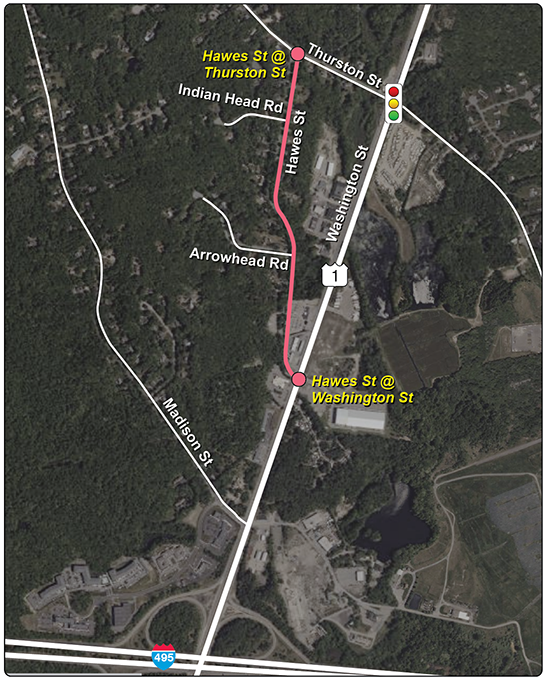
Figure 1 shows the roadways and intersections in the study area. Washington Street (Route 1) is a state-owned urban principal arterial and part of the National Highway System, which runs north-south. It is a two-way, four-lane, undivided roadway with a posted speed limit of 55 miles per hour (mph) in each direction. There are no sidewalks or bike lanes on Washington Street in the study area. Roadway shoulders are present on each side, which vary between two to eight feet wide due to the presence of turn lanes at the intersections. Washington Street connects to Interstate 495 in the south and multiple arterial roadways and business developments to the north. The area surrounding Washington Street is zoned as the Route 1 South District, which is currently attracting multiple commercial businesses.
Thurston Street is a town-accepted urban minor arterial that connects to Wrentham Center via East Street (Route 140). It is a two-way, two-lane street that runs east-west and has a posted speed limit of 30 mph except eastbound (east of Thurston Street) which is 25 mph. There are no sidewalks, bike lanes, or shoulders on Thurston Street within the study area. The surrounding land use is primarily residential.
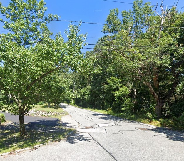
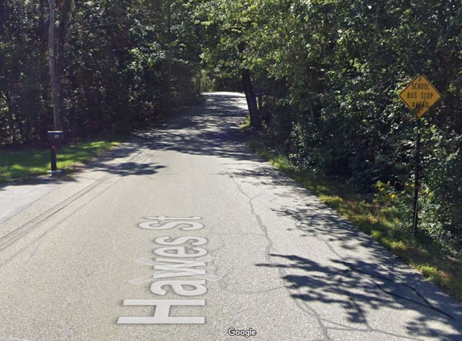
Hawes Street is a town-accepted local street that connects Washington Street to the south and Thurston Street to the north. It is a two-way, two-lane street with a posted speed limit of 30 mph and is approximately 0.7 miles in length. There are no sidewalks, bike lanes, or shoulders on Hawes Street in the study area. The land uses surrounding Hawes Street are mostly residential; however, there are a few properties owned for commercial purposes on Hawes Street near the Washington Street intersection.
Figure 1
Study Area
Source: Boston Region MPO staff.
Hawes Street and Commerce Boulevard intersect Washington Street to form an unsignalized four-leg intersection. It is a two-way stop-controlled intersection, with Hawes Street under stop control. The intersection has two lanes in each direction of Washington Street: a shared left-and-through lane and a shared through-and-right lane. There are no left turn lanes on Washington Street to turn onto Hawes Street, which increases the risk for people driving vehicles turning left onto Hawes Street because of the high speeds and volumes on Washington Street.
Figure 2
Intersection of Hawes Street and Washington Street
.jpg)
.jpg)
Note: Westbound view (top). Eastbound view (bottom).
Source: Google Street View (September 2019).
Hawes Street intersects Thurston Street to form an unsignalized T-intersection. It is a two-way, stop-controlled intersection, with Hawes Street under stop control. The intersection has one lane on each approach serving all traffic. Drivers on Washington Street heading to Thurston Street have two options: via Hawes Street intersection (unprotected left turn) or Thurston Street intersection (protected left turn).
While traveling on Hawes Street from the Washington Street intersection towards the Thurston Street intersection, there is an elevation and grade difference. Additionally, Hawes Street is narrow near the Washington Street intersection and widens closer to Thurston Street intersection.
Figure 3
Intersection of Hawes Street and Thurston Street
Source: Google Street View (October 2023).
Thurston Street intersects Washington Street to form a four-leg, signalized intersection. The intersection has an exclusive left-turn lane and two through lanes on each approach to Washington Street, one lane serving all traffic on each approach to Thurston Street. The left turns on Washington Street have protected phases for turning onto Thurston Street. Due to expected new developments on Washington Street, two traffic impact assessments have been conducted by consultants: one for the Washington Street and Hawes Street intersection, and one for the Thurston Street intersection. 1, 2
The focus of this study is Hawes Street and the intersections of Hawes Street with Thurston Street and Washington Street.
At the initial scoping meeting on January 4, 2024, MPO staff and staff from the Town of Wrentham discussed the concerns and scope of the study. Following this initial meeting, MPO staff and Town staff arranged a field visit on January 9, 2024, to observe the existing conditions in the study area. Our site visit suggested the following possible reasons for the cut-through traffic on Hawes Street.
During the site visit, we observed that most of the vehicles that travelled through the intersection of Washington Street at Hawes Street had Rhode Island license plates.
On April 16, 2024, MPO staff met with Town staff to share the preliminary findings of this study based on analyzing existing conditions and traffic count data. We continued to develop the study building on the discussion and comments received from the town.
Additionally, we received a phone call from a resident of the study area. The resident shared concerns related to cut-through traffic and visibility issues. This person also highlighted the bus stop signage and mentioned that children wait for the school bus on Hawes Street. We noted these concerns and considered them in our study.
We collected traffic data on the existing conditions in the study area during the week of January 29, 2024. The count data include the following:
The count locations and raw count data are included in Appendix A.
We also analyzed the crash reports and incident reports available for the study area to better understand the causes of these crashes.
Traffic volume data were collected at two locations in Hawes Street: south of Thurston Street and south of Arrowhead Road. We observed more traffic traveling southbound at both locations compared to northbound. The combined average weekly traffic volume south of Thurston Street is higher than south of Arrowhead Road, which could be because traffic volumes in this stretch of Hawes Street will also include residents.
Figure 4 shows the average weekday traffic volumes with both directional and combined average week volumes.
The combined average weekday traffic volumes in Hawes Street are reported below:
During the site visit, we observed a delivery vehicle entering Hawes Street from Thurston Street and exiting Hawes Street through Thurston Street. Such kinds of trips, where vehicles both enter and exit through Thurston Street, could explain the extra 90 vehicle trips south of Thurston Street (but not south of Arrowhead Road). These trips are likely generated from residential properties or are school-related trips, but these trips could be mischaracterized as cut-through traffic if both the entry and exit points are not observed in tandem.
Truck traffic on Hawes Street was raised as a major concern by residents. However, the traffic data we collected did not provide evidence to support this concern. Based on the traffic volume and classification data (recorded for 48 hours), we observed only two trucks travelling northbound on Hawes Street and continuing westbound onto Thurston Street.
To justify a truck exclusion zone, trucks need to account for at least five percent of the total vehicular traffic on a roadway. However, trucks make up only 0.2 percent of total traffic on Hawes Street. Therefore, the current volume of trucks in Hawes Street is not sufficient to justify a truck exclusion zone for Hawes Street.
Figure 4
Average Annual Daily Traffic (AADT)
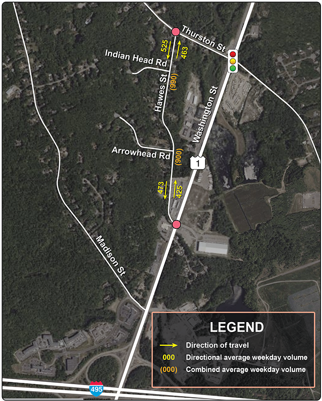
Source: Boston Region MPO staff.
Turning movement count data were collected for the Hawes Street and Thurston Street intersection at 15-minute intervals. TMC data account for passenger cars, trucks and buses, pedestrians, and bicycles travelling through the intersection. These data are recorded for the morning peak period between 6:00 AM and 9:00 AM as well as the evening peak period between 3:00 PM and 6:00 PM. Figure 5 shows the combined morning peak-hour and evening peak-hour volume at the intersection.
The combined peak-hour traffic volume data collected indicates that Hawes Street is used as a cut-through by people driving cars from Washington Street to Thurston Street, quite likely to avoid the traffic signal at the intersection of Thurston Street and Washington Street.3 Most vehicles on Hawes Street travel northbound and continue westbound on Thurston Street. We also observed considerable reverse traffic entering Hawes Street from Thurston Street. These data suggest that Hawes Street is being used as a cut-through by a significant number of drivers. Of the 144 vehicles we recorded on Hawes Street northbound, 107 vehicles (74 percent of vehicles) continued westbound on Thurston Street, while only 37 vehicles (26 percent of vehicles) continued eastbound on Thurston Street.
Only one pedestrian was observed walking east-west near the intersection of Hawes Street and Thurston Street when the count data were recorded.
Figure 5
Turning Movement Counts for Hawes Street at Thurston Street
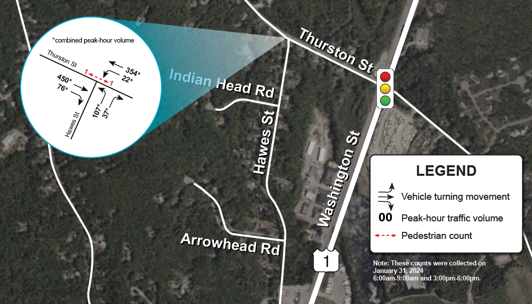
Source: Boston Region MPO staff.
Speeding was also noted as a matter of concern on Hawes Street, especially the cut-through traffic that was speeding through this residential street.
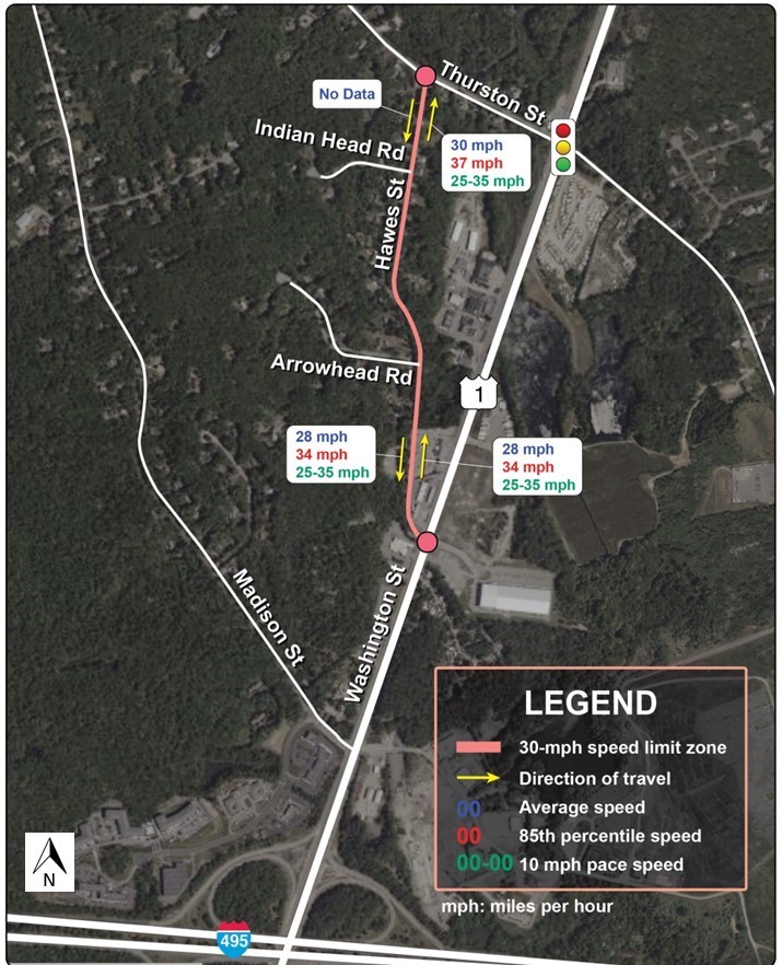
Similar to traffic volumes, we also collected vehicle speed data at two locations on Hawes Street: (1) south of Thurston Street; and (2) south of Arrowhead Road. Figure 6 shows the average speed, 85th percentile speed, 10 mph pace speed, and speed limit zones for Hawes Street.4
Table 1 summarizes the posted speed limit on Hawes Street, the average speeds at the two count locations on Hawes Street, the percentage of vehicles traveling within the posted speed limit, and the percentage of vehicles travelling over the speed limit (speeding).
Table 1
Summary of Speed Data
| Roadway |
Posted Speed Limit |
Average Speed |
Percent of vehicles |
Percent of Vehicles Speeding |
|---|---|---|---|---|
Hawes Street (south of Thurston Street) |
30 mph |
NB: 30 mph SB*: No data |
NB: 53% SB*: No data |
NB: 47% SB*: No data |
Hawes Street (south of Arrowhead Road) |
30 mph |
NB: 28 mph SB: 28 mph |
NB: 64% SB: 65% |
NB: 36% SB: 35% |
*Speed data are not reported for Hawes Street southbound, south of Thurston Street, because of errors in the data.
mph = miles per hour. NB = northbound. PSL = posted speed limit. SB = southbound.
Source: Boston Region MPO staff.
We observed the average speed of vehicles travelling on Hawes Street (for the directions with available data) to be within the current posted speed limit (30 mph). However, there is considerable speeding along the roadway (refer to the last column of Table 1 where the percentage of vehicles speeding is shown). The difference in grade and width along Hawes Street could be potential factors contributing to speeding. One approach to counteracting this behavior could be to reduce the speed limit to 25 mph as Hawes Street is a local residential street.
Figure 6
Speed Measurements
Note: Data are not reported for Hawes Street southbound, south of Thurston Street, because of errors in the data.
Source: Boston Region MPO staff.
We reviewed the crash reports and incident reports for the study area from 2019 to 2023 and did not find any reported crashes on Hawes Street. However, there were some crashes near the intersections of Hawes Street at Thurston Street and Washington Street. The crashes relevant to this study location are discussed below. We are not discussing crashes on Washington Street in this memorandum for two reasons: (1) it is out of the scope of this study; and (2) the Massachusetts Department of Transportation (MassDOT) is currently working on an improvement project on Washington Street.
Although there were no reported crashes on Hawes Street from 2019 to 2023, some crashes have occurred at the intersections of Hawes Street at Thurston Street and Washington Street. Data on these crashes are reported below in Tables 2 and 3. A detailed summary of crashes (from Tables 2 and 3) is discussed in Appendix F.
Table 2
Crashes near Hawes Street at Thurston Street (2019–23)
Statistics Period |
|
2019 |
2020 |
2021 |
2022 |
2023 |
Total number of relevant crashes |
|
0 |
0 |
1 |
0 |
0 |
Severity |
Property damage only |
0 |
0 |
1 |
0 |
0 |
|
Non-fatal injury |
0 |
0 |
0 |
0 |
0 |
|
Fatality |
0 |
0 |
0 |
0 |
0 |
|
Not reported/unknown |
0 |
0 |
0 |
0 |
0 |
Collison type |
Single vehicle |
0 |
0 |
1 |
0 |
0 |
|
Rear-end |
0 |
0 |
0 |
0 |
0 |
|
Angle |
0 |
0 |
0 |
0 |
0 |
|
Sideswipe, same direction |
0 |
0 |
0 |
0 |
0 |
|
Sideswipe, opposite direction |
0 |
0 |
0 |
0 |
0 |
|
Head-on |
0 |
0 |
0 |
0 |
0 |
|
Rear-to-rear |
0 |
0 |
0 |
0 |
0 |
|
Not reported/unknown |
0 |
0 |
0 |
0 |
0 |
Involved pedestrian |
|
0 |
0 |
0 |
0 |
0 |
Involved bicyclist |
|
0 |
0 |
0 |
0 |
0 |
Involved animal |
|
0 |
0 |
1 |
0 |
0 |
Note: Crashes discussed in the memo were filtered to only include crashes relevant to the study location.
Source: Town’s crash and incident records.
Table 3
Crashes near Hawes Street at Washington Street (2019–23)
Statistics Period |
|
2019 |
2020 |
2021 |
2022 |
2023 |
Total number of relevant crashes |
|
0 |
1 |
1 |
2 |
1 |
Severity |
Property damage only |
0 |
1 |
0 |
1 |
1 |
|
Non-fatal injury |
0 |
0 |
0 |
1** |
0 |
|
Fatality |
0 |
0 |
0 |
0 |
0 |
|
Not reported/ unknown |
0 |
0 |
0 |
0 |
0 |
Collison type |
Single vehicle |
0 |
0 |
1 |
0 |
0 |
|
Rear-end |
0 |
1 |
0 |
1 |
1 |
|
Angle |
0 |
0 |
1* |
0 |
0 |
|
Sideswipe, same direction |
0 |
0 |
0 |
0 |
0 |
|
Sideswipe, opposite direction |
0 |
0 |
0 |
0 |
0 |
|
Head-on |
0 |
0 |
0 |
0 |
0 |
|
Rear-to-rear |
0 |
0 |
0 |
0 |
0 |
|
Not reported/ unknown |
0 |
1 |
0 |
1** |
0 |
Involved pedestrian |
|
0 |
0 |
0 |
1** |
0 |
Involved bicyclist |
|
0 |
0 |
0 |
0 |
0 |
Involved motorcycle |
|
0 |
0 |
1* |
0 |
0 |
Involved animal |
|
0 |
0 |
1 |
0 |
0 |
Note: Crashes discussed in the memo were filtered to only include crashes relevant to the study location.
* This 2021 crash involved a motorcycle.
** This 2022 crash is a non-fatal injury (pedestrian) crash with unknown collision type.
Source: Town’s crash and incident records.
Several rear-end crashes have occurred on Washington Street due to vehicles waiting to turn left to access businesses along the street. As there are no dedicated left-turn lanes or center-turn lanes for these vehicles to wait safely, this results in a conflict and/or rear-end crashes. A number of those crashes may be due to vehicles entering and exiting the Interstate Plaza gas station and truck stop on Washington Street. However, proper turning lanes from this property onto Washington Street are absent. Additionally, safety concerns have been raised about pedestrians and drivers from the truck parking lot trying to approach the Interstate Plaza.5
The MassDOT District 5 team is currently working on a corridor improvement project on Washington Street (US Route 1) that includes the intersection where Hawes Street meets Washington Street. This project explores conceptual improvements on Route 1 in Wrentham, including safety, access, and accommodations for pedestrians and bicyclists. The project extends on Route 1 from the Foxborough town line (north extent) and the Interstate 495 (I-495) interchange (south extent), which is approximately 2.5 miles long. As of March 2024, this project is in the preliminary design phase.6
MassDOT is reviewing several improvement projects along the Route 1 corridor because of safety and operational issues as well as expected new developments. Presently, these projects have not been finalized or received approvals. These projects are intended to provide corridor improvements, which may include adding or reducing travel lanes, the construction of a median barrier, auxiliary turning lanes, driveway consolidation, pedestrian accommodations, and a separated bicycle facility along Route 1 to meet current MassDOT Complete Street standards to a practical extent.
The conceptual proposed improvements considered for the Hawes Street intersection at Route 1 include installing a new traffic signal and adding an exclusive northbound and southbound left-turn lanes on Washington Street for turning onto Hawes Street and Commerce Boulevard, respectively. Additional improvements may include pedestrian crossings across Washington Street and Commerce Boulevard.
The proposed improvements to Thurston Street would add exclusive left-turn lanes on both approaches to Route 1.
MassDOT is also evaluating cross-section designs for the Washington Street Corridor between I-495 and the Foxborough town line in the north, including the intersections in the study area. These designs may include a median along Washington Street.
After having evaluated the existing conditions, we propose the following recommendations.
Figure 7
Recommended “Right T Intersection” (W2-2) Sign

Source: Manual on Uniform Traffic Control Devices.
Figure 8
Recommended “Flashing Stop” Sign with LED Border

Source: Manual on Uniform Traffic Control Devices. Section 2A.11, page 48.
Figure 9
Existing Sight Distances at Indian Head Road
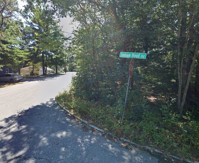
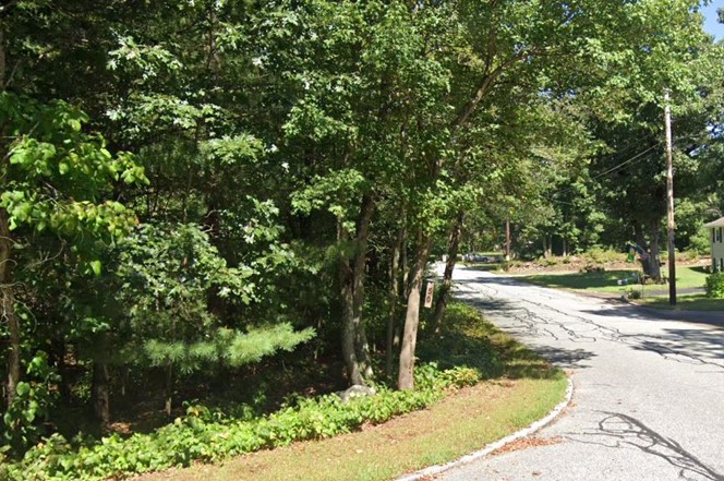
Note: Southbound view (top). Northbound view (bottom)
Source: Google Street View (September 2023).
Figure 10
Existing Sight Distances at Arrowhead Road
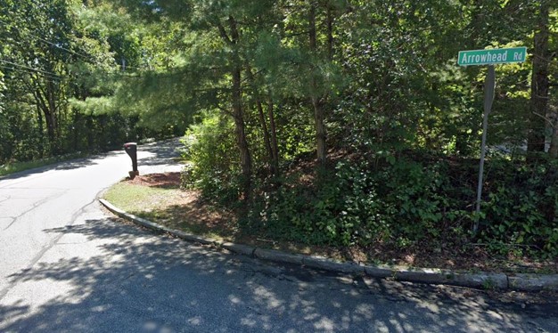
Note: Southbound view (top). Northbound view (bottom)
Source: Google Street View (September 2023).
Figure 11a
Existing “School Bus Stop Ahead” (S3-1) Sign in Hawes Street
Source: Google Street View (September 2023).
Figure 11b
Recommended “School Bus Stop Ahead” (S3-1) Sign
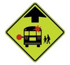
Source: Manual on Uniform Traffic Control Devices.
Figure 11c
Recommended “School Bus Turn Ahead” (S3-2) Sign

Source: Manual on Uniform Traffic Control Devices.
Figure 12
Sample Speed Table on Local Roadway
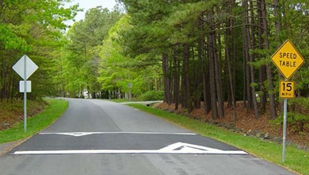
Source: Federal Highway Administration, Module 3: Toolbox of Individual Traffic Calming Measures Part 2.
Hawes Street has varying widths along different sections. We suggest assessing and maintaining a uniform width throughout. Existing drains along the roadway should also be considered as part of this assessment.
Figure 13
Existing Drains and Infrastructure in Hawes Street
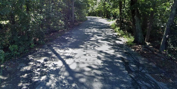
Source: Google Street View (September 2023).
Dead-ending Hawes Street is a good option to reduce the cut-through traffic speeding through the street. However, the resulting impact of dead-ending on emergency and rescue services needs to be considered. We recommend going forward with the Town’s consideration to block Hawes Street with a vegetative buffer north of the commercial properties, creating two dead ends (one for residential access from Thurston Street and another for commercial access from Washington Street) as indicated in Figure 16. This change would provide a safer environment for residents of Hawes Street, Arrowhead Road, and Indian Head Road to walk and bike on these roadways.
We recommend the following actions:
Figure 14
Animal Crossing Sign
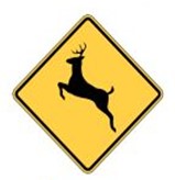
Source: Manual on Uniform Traffic Control Devices, Figure 2c-15.
Figure 15
“Left Turn Must Turn Left” (R3-7L) Sign
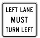
Source: Manual on Uniform Traffic Control Devices.
We recommend that Town staff work with MassDOT on the Washington Street Corridor project to address concerns of residents and businesses. Since MassDOT is currently working on a project on Washington Street that includes the intersection with Hawes Street, we outline a few considerations for the Washington Street project below.
It is important to analyze and identify whether signalizing the intersection of Hawes Street at Washington Street could attract more traffic to Hawes Street.
If this intersection were to be signalized, we strongly suggest installing a northbound left-turn restriction. When signalized, this will provide protected left turns onto Hawes Street and Commerce Boulevard. A portion of the northbound, left-turning vehicles and eastbound, right-turning vehicles at the Washington Street and Thurston Street intersection may instead choose to turn at the Hawes Street intersection, increasing traffic volumes on Hawes Street. More detailed analysis (perhaps using a regional travel model) would be required to assess future impacts of such an intervention, which is beyond the scope of this study.
If the intersection of Hawes Street at Washington Street is signalized, we recommend retaining the pedestrian-activated signal between the Interstate Plaza and truck parking (on the east side of Washington Street). Additional safety improvements may be necessary to provide safe crossing opportunities for truck drivers to access the Interstate Plaza from additional parking. Alerting vehicles about the upcoming signal near Interstate Plaza (that is activated by pedestrians) can be helpful to caution people driving about a potential need to come to a stop when the signal is activated by a pedestrian.
Even though the Interstate Plaza complex is a private property, we recommend reconfiguring the traffic flow pattern at the complex as a one-way entry with the other way being the exit. In addition to this, installing proper turning lanes and additional pedestrian safety measures from this property onto Washington Street may help reduce the number of rear-end crashes.
Similarly, even other privately-owned businesses can be encouraged to install stop signs near the exit as there are many crashes on Washington Street that involve exiting vehicles conflicting with vehicles that are already on Washington Street.
A 4,500 square foot convenience store, a gas station with six refueling pumps (a total of 12 fueling spots), and 25 parking spaces are being proposed at the vacant lot of 10 Commerce Boulevard. This project is part of the third phase of development of the Wrentham Business Center that was initially permitted in 2001. If this project were to include truck parking, it could potentially reduce the number of trucks (1) turning left from Washington Street to Interstate Plaza and (2) turning left onto Washington Street from Interstate Plaza.
An alternative if truck parking is not provided could be (1) to connect with the nearby truck parking lot (opposite 560 Washington Street) or (2) to install signage indicating the upcoming gas station and convenience store at 500 Thurston Street. These measures can be considered to provide clear directions to available convenience stores and gas stations in the area and provide easier navigation for large trucks.
Ensure that the height of traffic lights meet the latest standards since, in 2022, a truck was recorded hitting the traffic lights at Washington Street. If necessary, indicate any height restrictions for trucks as Washington Street is a corridor with heavy truck traffic.
All of our proposed recommendations on Hawes Street and the adjacent intersections are summarized in Figure 16.
Figure 16
Proposed Improvements to Hawes Street and Adjacent Intersections
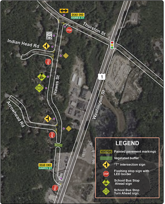
Source: Boston Region MPO staff.
Staff from the Town of Wrentham requested that MPO staff investigate concerns raised by residents about truck traffic, cut-through traffic, and speeding on Hawes Street, a residential street in Wrentham, Massachusetts. In addition to Hawes Street, we also studied its adjacent intersections (Hawes Street at Thurston Street and Washington Street) and evaluated them to address these issues and safety concerns. Since MassDOT is currently working on an improvement project on Washington Street (which includes the Hawes Street at Washington Street intersection), our recommendations in this study are focused on Hawes Street. We also assessed the extent to which Hawes Street is being used as a cut-through. Our recommendations and the considerations discussed are based on our observations from a site visit and inferences from analyzing traffic data we collected in the study area.
Our suggested improvements include both short-term and long-term recommendations. Short-term recommendations include safety improvements that are relatively easy to install and do not require significant time or resources to plan, design, and implement—such as pavement markings and signage—while improving safety for all road users. Our long-term recommendations include interventions that are more permanent, may have an extensive permitting process, and may require planning, designing, and coordination with others (such as agencies with roadway jurisdiction, residents, businesses, and property owners) throughout the process. Chapter 90 Funds can be used to fund short-term improvements.7 For implementing long-term recommendations, Town staff can coordinate with MassDOT on locations that are under MassDOT’s jurisdiction. A detailed summary of potential safety enhancements is outlined in Appendix G. MassDOT’s project development process and schematic timetable are attached in Appendix H.
CIVIL RIGHTS NOTICE TO THE PUBLIC
Welcome. Bem Vinda. Bienvenido. Akeyi. 欢迎. 歡迎
You are invited to participate in our transportation planning process, free from discrimination. The Boston Region Metropolitan Planning Organization (MPO) is committed to nondiscrimination in all activities and complies with Title VI of the Civil Rights Act of 1964, which prohibits discrimination on the basis of race, color, or national origin (including limited English proficiency). Related federal and state nondiscrimination laws prohibit discrimination on the basis of age, sex, disability, and additional protected characteristics.
For additional information or to file a civil rights complaint, visit www.bostonmpo.org/mpo_non_discrimination.
To request this information in a different language or format, please contact:
Boston Region MPO Title VI Specialist
10 Park Plaza, Suite 2150
Boston, MA 02116
Phone: 857.702.3700
Email: civilrights@ctps.org
For people with hearing or speaking difficulties, connect through the state MassRelay service, www.mass.gov/massrelay. Please allow at least five business days for your request to be fulfilled.
1 Traffic Impact Study, Proposed Gas Station & Convenience Store, Commerce Boulevard, Wrentham, Massachusetts. Prepared for Edgewood Development Company, LLC, May 2023.
2 Transportation Impact Assessment, Proposed Warehouse, Washington Street, Wrentham, Massachusetts. Prepared for Bluewater Property Group, New York, New York, September 2021.
3 The peak-hour volume is the total traffic volume recorded during the hour with the highest traffic flow (i.e., four consecutive 15-minute intervals). The combined peak-hour volume is the sum of peak-hour volumes from both AM and PM peak periods combined.
4 According to the Federal Highway Administration (FHWA), “The 10 mph pace is the 10 mph range encompassing the greatest percentage of all the measured speeds in a spot speed study.” See the FHWA’s Methods and Practices for Setting Speed Limits: An Informational Report, https://safety.fhwa.dot.gov/speedmgt/ref_mats/fhwasa12004/fhwasa12004.pdf.
5 The Sun Chronicle, https://www.thesunchronicle.com/news/local_news/wrentham-man-charged-in-route-1-accident-that-left-taunton-man-dead/article_1448b9a7-07f1-52ce-bb3b-8311a8dce297.html.
6 MassDOT Project Information, Wrentham—Corridor improvements on Route 1,
https://hwy.massdot.state.ma.us/ProjectInfo/Main.asp?ACTION=ViewProject&PROJECT_NO=608497.